

Life-threatening conditions expected as Hurricane Irma barrels through as a Category 5

By Jordan Root and Renee Duff
AccuWeather meteorologist
Accuweather Weather Center – “Irma is expected to bring deteriorating and perhaps devastating conditions across the Leeward Islands into Wednesday,” AccuWeather Hurricane Expert Dan Kottlowski said.
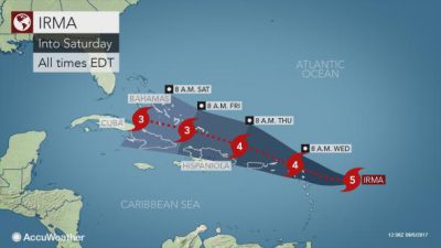
Irma strengthened to a Category 5 hurricane with maximum sustained winds of 175 mph (280 km/h) on Tuesday morning, becoming the strongest storm in the Atlantic Basin since 2007. Irma will pass near or over the Leeward Islands Tuesday night into Wednesday.
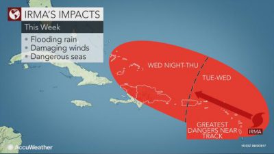
The current track of Irma will put Antigua and Barbuda, Montserrat, St. Kitts and Nevis, Anguilla and the U.S. and British Virgin Islands, in the brunt of the storm’s rain and wind during this time. Impacts could also be felt across the far northern Windward Islands as well.
Irma poses an imminent danger to these areas, where preparations for the storm should be rushed to completion.
Widespread power outages and significant damage to trees and structures are likely where the eye of the storm passes directly over or makes its closest approach. The power may be out for weeks in some communities.
Rough surf will spread outward from the storm, leading to dangerous swimming and boating conditions along the east-facing beaches of the Lesser Antilles. Small craft should head to port and remain there until Irma has passed.
“We are expecting very rough and dangerous surf along with damaging tropical-storm-force and hurricane-force winds over the northern Leeward Islands, and tropical-storm-force winds over the southern Leewards to perhaps the northern Windward Islands, mostly in gusts,” Kottlowski said.
Irma will track near Puerto Rico Wednesday and Wednesday night, delivering flooding rain and damaging winds along with the threat for mudslides.
Rainfall will be heavy enough to trigger flash flooding, mudslides and road washouts. Amounts of 4 to 8 inches of rain can be expected on the islands.
Irma track 9.5 AM
“Farther to the west, residents and interests on Hispaniola, the Turks and Caicos Islands, the Bahamas and eastern Cuba should closely monitor the progression of Major Hurricane Irma,” Kottlowski said.
A track near or over these locations is becoming increasingly likely towards the end of the week, which would bring life-threatening conditions to residents and any vacationers.
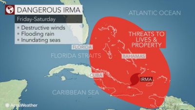
The greatest impacts would be felt Thursday and Thursday night for Hispaniola and the Turks and Caicos Islands. By Friday, Cuba and the Bahamas could begin to be severely impacted. These areas should prepare for devastating hurricane conditions.
However, fluctuations in Irma’s strength and track are expected over the next couple of days, so the exact track the hurricane will take is still unknown. Regardless, residents are urged to prepare now and have a plan in place.
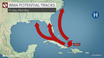
Uncertainty greatly increases heading into the weekend and next week as Irma tracks closer to the United States coastline.
Given the uncertainty that remains, all interests along the Gulf and East coasts should closely monitor the forecast path of Irma this week and review emergency and evacuation procedures in case they need to be implemented.
Behind Irma, a disorganized area of showers and thunderstorms located hundreds of miles southwest of the Cabo Verde Islands will need to be monitored for potential development.
This system will move into a favorable environment for organizing and gaining strength as it moves to the west-northwest toward the Lesser Antilles during the latter part of this week.
The next storm in the Atlantic Basin would acquire the name Jose.