

AccuWeather: Tuesday storm brings major disruption to northeast
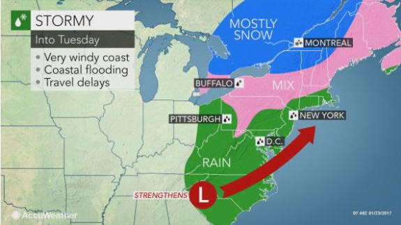
The same storm that triggered the outbreak of tornadoes and severe thunderstorms across the South over the weekend will sweep up the East Coast.
Rain to ease dryness, trigger localized flooding
An area of locally drenching rain will advance north and east with the storm.
One to 2 inches of rain can fall along the swath from Pittsburgh to Washington, D.C., New York City and Boston by Tuesday night.
 The threat for flooding will be rather localized, mainly staying confined to streets and poor drainage areas.
The rain, combined with areas of low clouds and fog, could lead to delays on the road and at the airports early this week.
While the rain can lead to disruptions to daily activities, it will help to fill up low streams, lakes and reservoirs. According to the latest U.S. Drought Monitor, much of the Northeast is suffering from moderate to extreme drought.
Snow, ice to cover interior Northeast
Wet snow and ice will comprise a majority of the event for northern Pennsylvania, much of New York state and New England and threaten to cause slippery travel.
As cold air is pulled southward or manufactured by the storm, some areas that start as rain will changeover to snow and ice.
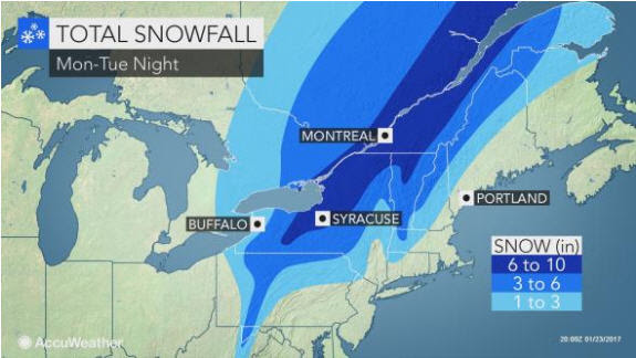 There will be areas from the central Appalachian states to southeastern Canada where mostly snow falls. Localized snow amounts could exceed 6 inches.
“In central and northern Pennsylvania, southeastern New York state, western Maryland, eastern West Virginia and central New England, this will be an elevation snowstorm,” according to AccuWeather Senior Meteorologist Alex Sosnowski.
A heavy amount of snow will accumulate over the ridges, while very little snow may accumulate over the low terrain in the valleys. A couple of degrees may determine whether heavy rain or snow falls, along with a wintry mix.
“A difference in elevation by a few hundred feet can mean the difference between a little snow and slush and several inches of snow,” Sosnowski said.
Travel along Interstates 80, 81, 87, 90, 91 and 93 could be slower than normal due to areas of rain, slush and snow.
The weight of the heaviest snow can down tree branches and power lines, threatening to cause sporadic power outages.
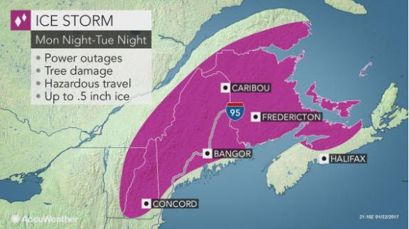 Where ice mixes with snow, accumulations will be cut down significantly. However, travel will remain slick.
A more prolonged ice event will also put northern New England at risk for power outages and extremely dangerous travel. However, where more precipitation falls as sleet instead of freezing rain or wet snow, fewer power outages will occur.
Howling winds to cause dangerous surf
High wind gusts past 50 mph will buffet coastal areas from the Delmarva to eastern Maine. The high winds will push a large amount of water toward the coast.
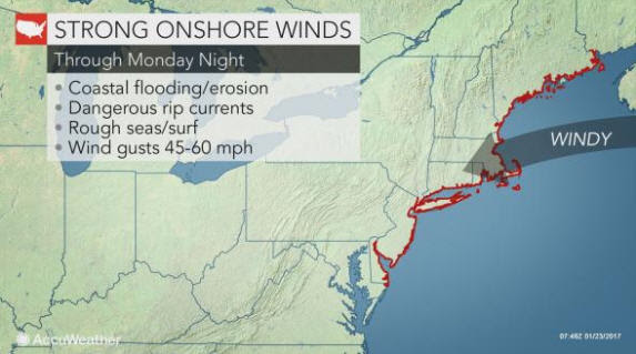 “The wind along with the drenching rain and soft soil could knock down trees and power lines, resulting in power outages,” AccuWeather Meteorologist Brett Rathbun said. “The coastal flood threat will be greatest at times of high tide.”
The crashing waves threaten to eat away at the beaches and cause erosion up and down the mid-Atlantic and New England coasts. The seas will be dangerous for small craft.
Brief surge of warmth to arrive at midweek
In the wake of the storm, the door will be opened for mild air to make a brief return in the Northeast.
High temperatures will range from the 50s to lower 60s F across the mid-Atlantic to upper 40s across southern New England. Temperatures at this level are more typical of late March.
A new wave of cold air will abruptly end the mild spell late this week.
By Renee Duff, Meteorologist for AccuWeather.com
For more information, contact:
Justin Roberti / 814.235.8756 / [email protected]
Or call our 24-hour press hotline:
814-235-8710