Hurricane Irma lash Georgia to the Carolinas with damaging winds, flooding and severe weather

By Renee Duff, Meteorologist for AccuWeather.com
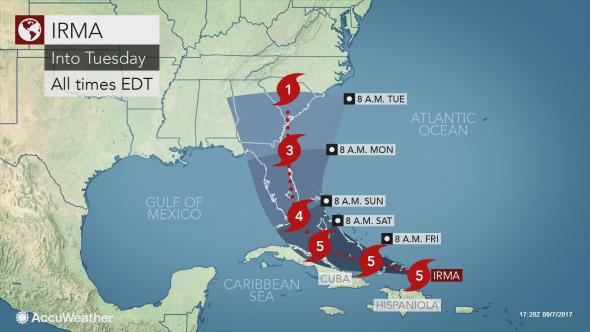
AccuWeather Global Headquarters – AccuWeather reports a After unleashing severe impacts on Florida, Irma will make a beeline for the Southeast coast, likely making landfall between Georgia and the Carolinas early next week.
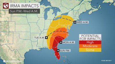
Those from Georgia to the Carolinas will need to be on alert for direct impacts from Irma beginning as early as late Sunday and Monday. Preparations should be rushed to completion in these areas.
Residents, visitors and government officials in these areas need to prepare now for lengthy power outages, flooding and major delays and disruptions. Contacting a variety of professionals similar to Buric Heating and Air Conditioning will be critical to recovering after such an event. Having a cold home after the main structural damage has been corrected is a vital part of the recovery process. Those along the coast should heed all mandatory evacuations and strongly consider leaving if a voluntary evacuation is ordered.

Irma is expected to move back out over water along the middle or northern east coast of Florida Sunday night and during Monday then northward for a landfall along the Georgia or South Carolina coast late Monday, according to AccuWeather Hurricane Expert Dan Kottlowski.
This would be the first or second landfall, depending on whether or not the center of Irma crosses over Florida early in the weekend.
Should Irma make landfall along the Southeast coast, it would likely occur from near Savannah, Georgia, to Wilmington, North Carolina, early next week. These cities as well as Charleston and Myrtle Beach, South Carolina, should anticipate severe impacts from Irma.

The strength of Irma by the time it reaches the Southeast coast will largely depend on how much interaction the storm has with Florida and the Bahamas. Regardless, Irma is expected to remain a large and dangerous hurricane that should be taken very seriously.
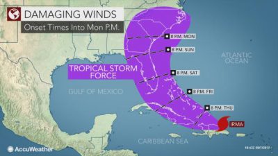
Tropical-storm-force conditions are expected to arrive along the coast later Sunday with rain and wind intensifying through Sunday night and into Monday morning.
Power outages, tree damage and structural damage will be most widespread along and just inland of the coast. However, hurricane-force wind gusts can occur 100 to 150 miles away from the coast, triggering damage farther inland over Georgia and the Carolinas.
Isolated tornadoes will be a concern on the northeast side of where landfall occurs. A large storm surge will inundate coastal communities on this side of the storm as well.
“Stay tuned to local government information and AccuWeather.com for timing of the hurricane’s progress, and remember it is not too early to prepare to leave; pack bags, gas up your car and prepare your property now,” Evan Myers, AccuWeather expert senior meteorologist and chief operating officer, said.
Irma will move to the north and west beyond landfall. While widespread damaging winds will become less of a concern farther inland, the threat for flooding will mount as Irma’s rain expands.
It is important for people to get ready with emergency services to try and help them after the flooding has occurred. For example, the houses that have been flooded will need to get water restoration to make sure their property is structurally sound enough for them to return home. On top of this, water pipes and drainage systems are vulnerable to bursts due to the increased rainfall so you could visit website here, for one plumbing service that offers emergency support.

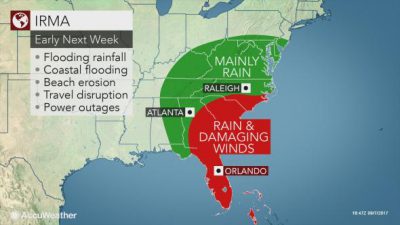
Heavy rain is forecast to spread inland toward the southern Appalachians from Monday to Tuesday, potentially leading to extensive flooding due to the mountainous and hilly terrain of northeastern Georgia, western South Carolina, eastern Tennessee and western North Carolina.
There is concern for serious flooding problems across Georgia and the Carolinas from Irma, according to Dr. Joel N. Myers, founder, president and chairman of AccuWeather.
Mudslides and road washouts will be possible. At the very least, disruptions to travel and outdoor plans will occur.

Atlanta; Knoxville, Tennessee; and Charlotte, North Carolina, could endure wind gusts to tropical storm strength. Sporadic power outages can occur as the soil becomes saturated.
The amount of rain that falls will lessen significantly beyond the Southeast as Irma runs into a large area of dry air over the Ohio Valley, Great Lakes and Northeast. Flooding will become more of a concern on the local level.
Still, locations such as Louisville, Kentucky; Cincinnati; Charleston, West Virginia; Richmond, Virginia; Pittsburgh; Washington, D.C.; Baltimore and Philadelphia, should anticipate wet, dreary and cool conditions around midweek. Travel disruptions can mount during this time.
Some of Irma’s rain may reach New England later next week.


