We’re more than halfway done with meteorological fall, but so far the season has felt much more like an extension of summer. Since Sept. 1, San Antonio has seen an average high of 91.9 degrees — just three degrees cooler than the city’s average temperature during June, July, and August. The city is also on pace for its eighth-warmest fall on record, with October potentially ranking as the second-warmest in history.
Will our unusually warm fall continue into winter? Last week, the National Oceanic and Atmospheric Administration released its official winter outlook, detailing the chances that Texas could face a colder or warmer season than usual. Here’s what the outlook reveals.
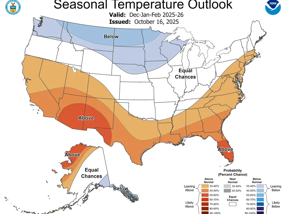
NOAA winter outlook
NOAA’s outlook predicts warmer weather this winter for most of the southern United States, including nearly all of Texas. Meteorological winter runs from Dec. 1 through Feb. 28.
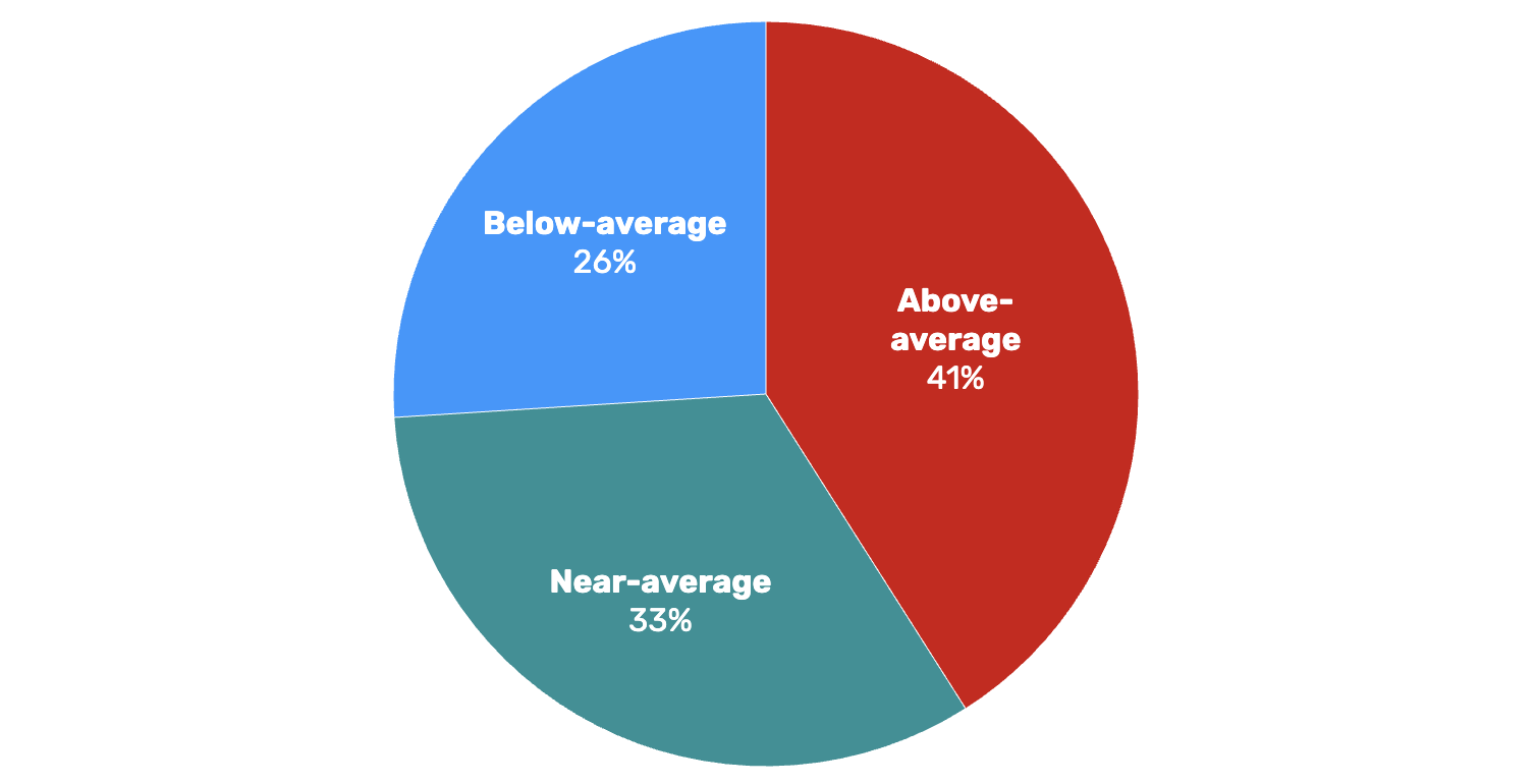
However, that doesn’t guarantee a mild season for Texas — the outlook is based on probabilities, not certainties. In San Antonio, specifically, there’s a 41% chance of above-average temperatures, a 33% chance of near-average temperatures, and a 26% chance of below-average temperatures this winter.
So, if you’re a fan of cold weather, there’s still some hope. While South Texas is more likely to see a warmer winter, there’s still about a one-in-four chance that it could be colder than average.
Winter outlook
San Antonio: Shown are the chances of above, below, or near-normal temperatures during meteorological winter
The likelihood of a colder winter gradually rises as you move farther north. Austin has a 28% chance of below-average temperatures, Waco sits at 30%, and Dallas has a 33% chance of a colder season.
When it comes to precipitation, much of Central, South, and West Texas are expected to be drier than normal this winter. In San Antonio, NOAA’s outlook shows a 42% chance of below-average rainfall, a 33% chance of near-normal precipitation, and a 25% chance of wetter-than-average conditions.
Effects of La Niña
NOAA’s outlook reflects a typical La Niña winter pattern, which the agency’s Climate Prediction Center confirms has officially returned and is likely to continue through the season.
During La Niña, a semi-permanent high-pressure system often develops over the northern Pacific Ocean, pushing the polar jet stream farther north. As a result, Texas usually sees fewer cold fronts, leading to warmer and drier winters.
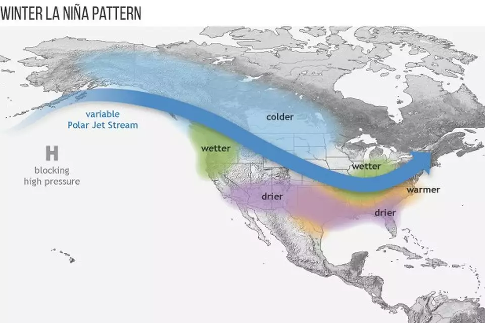
La Niña tends to produce warmer and drier weather for us in Texas, often leading to above-normal warmth in winter
In San Antonio, roughly 65% of La Niña winters since 1950 have brought above-average temperatures, averaging 1.3 degrees warmer than non-La Niña winters. Rainfall has also been lower, with the city averaging just 4.07 inches of precipitation—about 28% drier than in non-La Niña years.
It’s important to note that while cold fronts occur less often during La Niña winters, powerful ones can still sweep through and trigger widespread freezing conditions. The historic Texas freeze in February 2021, for instance, happened during a La Niña pattern.
Farmers’ Almanac forecast
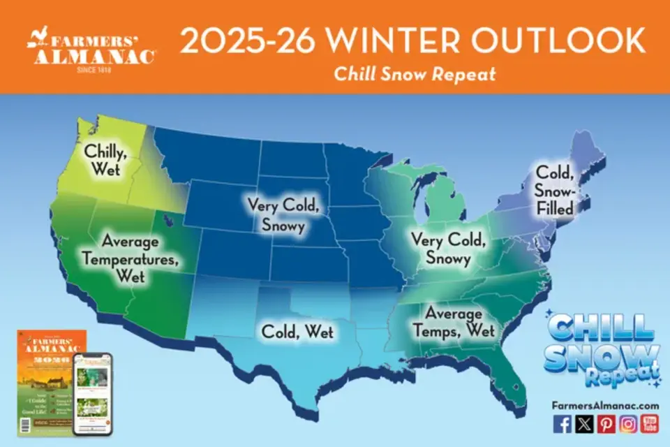
The Farmers’ Almanac forecast for the 2025-26 winter promises cold and wet weather across Texas. SRC – Farmers’ Almanac
The Farmers’ Almanac, which has issued seasonal weather forecasts since 1818, offers a very different take on the upcoming winter. According to the publication, this winter is “shaping up to be a wild ride,” predicting that Texas will see a “wetter-than-average winter with periodic cold snaps.”
The almanac’s long-range outlook also points to several chances for snow in northern Texas, though the odds are much lower across the southern part of the state.
However, the Farmers’ Almanac doesn’t have a strong record for accuracy. A University of Illinois study found its monthly precipitation forecasts were correct about 52% of the time, while temperature forecasts were accurate just 51% of the time — only slightly better than flipping a coin.


Leave a Reply