
Severe Weather Possible as System Moves Through
Severe Weather Possible as System Moves Through
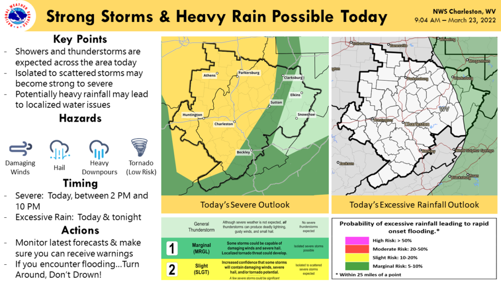
RACINE, Ohio – The National Weather Service has issued a Hazardous Weather Outlook for the region including Meigs County and the surrounding areas.
Beginning this afternoon showers and thunderstorms are expected. A slight risk of severe weather exists for locally damaging winds, hail or possibly a tornado this afternoon into this evening.
A large low pressure system pulls a cold front through the area tonight. Showers and thunderstorms are expected to develop amid a warm and windy environment ahead of the advancing cold front this afternoon. As a result, the thunderstorms could become strong to severe. Heavy downpours are also possible, especially in thunderstorms. Outside of the thunderstorms, wind gusts of around 30 mph, even 40 mph over the higher ridges, are expected today. Temperatures will trend cooler from Thursday into the weekend, and precipitation chances return as several disturbances pass by.
Forecast for the Week
This Afternoon
A chance of showers and thunderstorms, then showers and possibly a thunderstorm after 4pm. Some of the storms could be severe. High near 74. South wind 11 to 13 mph, with gusts as high as 25 mph. Chance of precipitation is 80%. New rainfall amounts between a tenth and quarter of an inch, except higher amounts possible in thunderstorms.
Tonight
Showers and thunderstorms, mainly before 9pm. Some of the storms could be severe. Low around 45. South wind around 10 mph becoming west in the evening. Winds could gust as high as 20 mph. Chance of precipitation is 80%. New precipitation amounts of less than a tenth of an inch, except higher amounts possible in thunderstorms.
Thursday
Partly sunny, with a high near 60. Light south wind becoming southwest 5 to 9 mph in the morning. Winds could gust as high as 20 mph.
Thursday Night
Partly cloudy, with a low around 40. Southwest wind 3 to 5 mph.FridayA 40 percent chance of showers, mainly after 8am. Mostly cloudy, with a high near 52. West wind 5 to 10 mph, with gusts as high as 20 mph.
Friday Night
A 50 percent chance of showers. Mostly cloudy, with a low around 37. New precipitation amounts between a tenth and quarter of an inch possible.SaturdayShowers likely, mainly before 2pm. Partly sunny, with a high near 46. Chance of precipitation is 60%.
Saturday Night
A 30 percent chance of showers before 9pm. Mostly cloudy, with a low around 29.
Sunday
Mostly sunny, with a high near 48.
Sunday Night
Partly cloudy, with a low around 30.
Monday
Mostly sunny, with a high near 52.
Monday Night
Partly cloudy, with a low around 35.
Tuesday
A 30 percent chance of showers. Partly sunny, with a high near 61.