Winter’s icy air, rounds of snow to blast eastern US into February
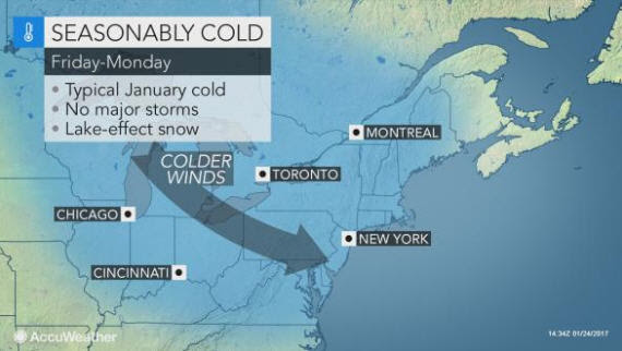
EASTERN UNITED STATES: AccuWeather reports much colder air will sweep into the eastern United States later this week and will have staying power well into February.
A storm producing snow over the Upper Midwest into Thursday will help usher in the change in the weather pattern.
The return to colder weather will follow another spike in temperatures more typical of March in many locations prior to the end of this week.
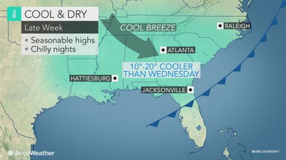
By Friday, temperatures will be slashed by 10 to 20 degrees Fahrenheit in most locations, compared to peak levels on Wednesday in the Midwest and Thursdayalong the Atlantic seaboard.
Highs in the 40s and 50s across the north and the 60s and 70s in the south will be replaced with highs in the 20s and 30s in the north and the 40s and 50s in much of the south.
“In parts of the Southeast states, temperatures can fall a few degrees below average for a few days during the pattern,” according to AccuWeather Lead Long-Range Meteorologist Paul Pastelok. “This is because the core of the cold air will be directed south of the Great Lakes and the Northeast.”
Factoring in gusty winds and snowy conditions at times, AccuWeather RealFeel® Temperatures can dip 10 to 20 degrees lower than the actual temperature by this weekend.
“While the air will be far from being extremely cold, the sudden change will be a shock to some people and will feel 30 to 40 degrees colder compared to many days over the past couple of weeks,” Pastelok said.
In addition to the return of typical temperatures for late January and early February, snow is in store for some locations.
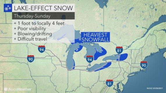
“Cold air sweeping past the Great Lakes will pick up moisture and result in episodes of lake-effect flurries and heavier squalls over parts of the Upper Midwest, central Appalachians and interior Northeast,” Pastelok said.
Motorists in the Interstate 75, I-79, I-80, I-81, I-90 and I-96 corridors should be prepared for sudden changes to visibility and poor road conditions during the pattern.
There is the potential for snow to fall at the rate of 1 to 2 inches per hour in the heaviest squalls. Where bands of snow persist, some locations can pick up a foot of snow in 24 hours or less.
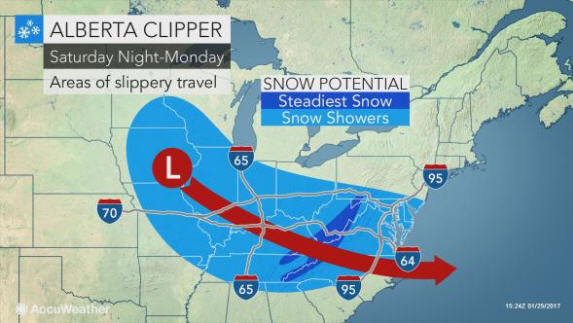
In addition to the lake-effect snow, fast-moving storms diving in from western Canada, known as Alberta clippers, will be part of the weather pattern. These storms often bring a general swath of light to moderate snow well away from the Great Lakes.
One such clipper storm will drop southeastward and can bring enough snow to make roads slippery from the Midwest this weekend to parts of the interior South and the Atlantic coast by Monday.
Areas that could receive a coating of snow include parts of the Ohio and Tennessee valleys, as well as the mid-Atlantic region of the I-95 corridor.
Another clipper storm may swing southeastward by the middle of next week.
“While the northwesterly flow of cold air will be enough to prevent many major storms from spinning up along the Atlantic coast, the flow could back off enough to allow one or two major coastal storms through the first half of February,” Pastelok said.
As a result, the chance for a large coastal storm exists. Should a coastal storm develop, it could bring substantial snow to part of the East and perhaps severe weather in the Southeast during the first week or two of February.
By Alex Sosnowski, Senior Meteorologist for AccuWeather.com


