After more than 100 years, will 2026 bring a direct hurricane hit to Tampa? What about Miami, which hasn’t seen one since Andrew struck 34 years ago? Could southern New England face its first hurricane in decades?
Experts cannot answer these questions yet, but they identify all three locations as among the nation’s most “overdue” for a direct hurricane strike.
AccuWeather forecasts point to an unusual “hurricane hiatus” in these three areas. Research from Michael Ferragamo, a freelance hurricane researcher and soon-to-be graduate of the University of Oklahoma, confirms that these locations have gone without a hurricane for an uncommonly long period.
“Populations in all of these regions have grown substantially since the last major impacts,” AccuWeather hurricane expert Alex DaSilva told USA TODAY. “Many residents have never experienced a hurricane and may not understand evacuation zones or proper preparation, which raises the risk.”
What makes these locations so vulnerable?
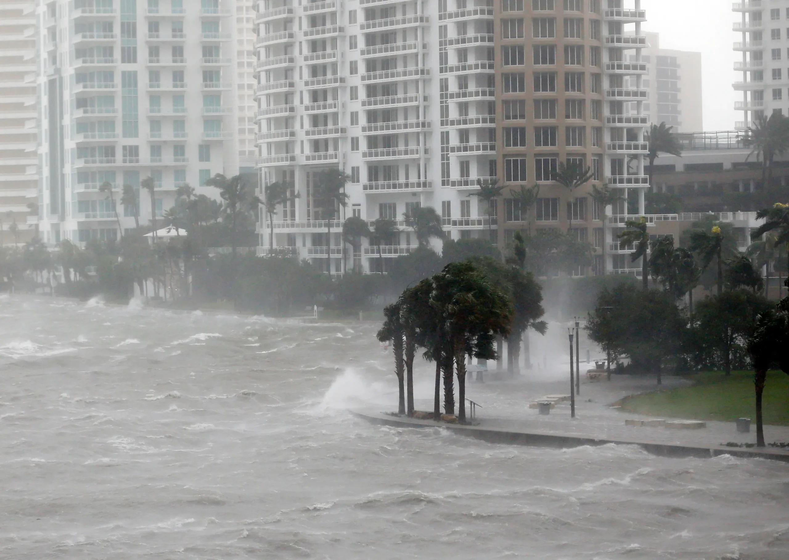
In Florida, DaSilva describes both Tampa and Miami as “very vulnerable.” “Both sit in low-lying areas and face high risks of storm surge flooding, and both have experienced rapid development in recent decades. Tampa dodged a bullet when Hurricane Milton passed just to the south. A slightly northward shift in that track could have triggered catastrophic impacts.”
In the Northeast, areas from New York City through Providence, Rhode Island, also face high storm surge vulnerability.
Tampa: ‘Very, very lucky’
Florida’s second-most populous metro area (behind Miami) hasn’t experienced a direct hit since 1921, when an unnamed storm struck the city, killed eight people, and caused $10 million in damages (equivalent to $170 million to $185 million today).
Hurricane Milton in 2024 came dangerously close to Tampa. However, “Tampa’s remarkable streak of avoiding a direct hit from a major hurricane continued with Milton,” DaSilva said.
While Milton delivered impacts, the city escaped the worst of the storm — and the storm surge. DaSilva says no geographical, topographical, or even meteorological reason explains Tampa’s long streak. “They got very, very lucky,” he said.
“The typical ‘return interval’ there runs around 10 years, so depending on how you classify Milton, Tampa could still qualify as overdue for a more direct and severe hit.” (A return interval, or return period, represents the average time between hurricanes at a specific location, based on historical data — not a schedule or prediction.)
Colorado State University hurricane researcher Phil Klotzbach shares DaSilva’s view: “Tampa stands as another good example of a city with several close calls but no direct landfalls in recent years,” citing Hurricanes Charley (2004), Irma (2017), and Idalia (2023).
Miami: ‘Eerily quiet’
“Miami and the entire east coast of Florida has been eerily quiet since 2004,” Klotzbach said. “The only hurricane landfall along the Florida east coast since Jeanne in 2004 was that sprawling mess Nicole in 2022. Of course, Miami had quite the scare from Irma in 2017,” he said.
DaSilva calls “Miami one of the most overdue areas. The average return interval for a hurricane there runs about every 6 to 8 years, yet it has been since 2005 since a direct hit. That puts South Florida well beyond its historical frequency.”
Hurricane Andrew in 1992 remains South Florida’s worst storm on record in terms of structures damaged or destroyed, and held the title of costliest in monetary terms until Hurricane Irma surpassed it 25 years later.
Ferragamo also notes that Florida’s east coast has seen very few hurricane landfalls recently, “which stands in stark contrast to the seven hurricanes that struck between 1945 and 1950!”
Southern New England: ‘It will be catastrophic’
Southern New England, including Providence, also qualifies as significantly overdue, DaSilva said. “The typical return interval runs about 17 to 20 years, but the last direct hurricane landfall there was Hurricane Bob in 1991. That stretches more than three decades ago.”
A former Massachusetts resident, Klotzbach said “I can attest that it’s been a long time since a significant hurricane impacted that region.”
While Bob brought destruction, the scale and severity of death and devastation from the ferocious hurricane of 1938 remains mostly unmatched in New England.
The 1938 hurricane killed as many as 682 people and struck as a Category 3, with winds of 115 to 120 mph. It also moved at nearly 50 mph, leaving little warning and producing catastrophic surge and wind across Connecticut, Rhode Island, and Massachusetts.
DaSilva said that “Last summer, our team highlighted how the Northeast faces an overdue hurricane and ran a scenario. If the Great New England Hurricane of 1938 hit the same region with the same storm surge, flooding and wind impacts now, AccuWeather experts estimate the total damage and economic loss would reach $440 billion.”
More recently, Hurricane Bob became the last landfalling hurricane in 1991, Ferragamo said. “Since then, kids have grown up and reached their 20s & 30s in the region, and still haven’t experienced a hurricane strike.”
“My biggest concern for New England comes in the form of major hurricanes — the once in a lifetime monsters, like in 1938 or Carol in 1954. Residents have absolutely no idea how bad a hurricane can be in the region, and when another one does hit, it will be catastrophic, even if it’s a Category 2.”
What are the worst cities, locations for hurricanes in the US?
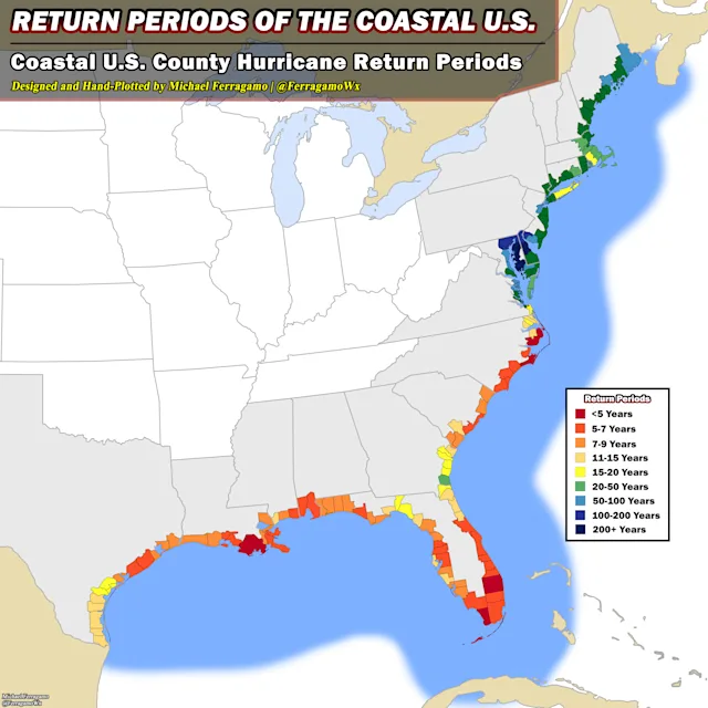
A map shows the hurricane “return periods” of the coastal United States. A return period is the average amount of time between hurricanes at a specific location, based on historical data — not a schedule or prediction.
The map (above) displays the hurricane “return periods” of the entire coastal United States. A return period, also known as a “return interval,” is the amount of time between hurricanes at a specific location. It is based on historical data, and is not a schedule or a prediction.
The more frequent the return period (red on the map), the more often hurricanes historically hit that area.
The map was for Ferragamo’s capstone project in his last semester at the University of Oklahoma. “For the return period map, I implemented a 30-mile radius around counties (to account for the average diameter of hurricane-force winds in a storm).”


Leave a Reply