MANILA, Philippines — A powerful magnitude 7.8 offshore earthquake struck the southern Philippines on Monday, killing at least 32 people, injuring more than 200 others — most of them in damaged buildings — and pushing a 1-meter (3-foot) tsunami onto nearby coasts.
Several buildings collapsed and key infrastructure suffered heavy damage in the city of General Santos, while tsunami damage hit at least one coastal village. Indonesia, Palau, and even southern Japan recorded smaller waves.
The quake also set off a landslide in Sarangani province that killed 13 villagers. Disaster-mitigation official Rene Punzalan told the DZBB radio network that the landslide struck homes in the mountainous town of Glan. Four more villagers died in Sarangani for reasons that remain unclear, he said.
“It’s a major earthquake,” said Teresito Bacolcol, director of the Philippine Institute of Volcanology and Seismology, urging people to seek advice before returning to damaged buildings and houses that aftershocks could bring down.
“Our pickup truck suddenly jerked and I thought we had a flat tire,” said Rod Sosmeña, regional director of the Office of Civil Defense, speaking to The Associated Press from the hard-hit port city of General Santos, where he was traveling when the quake struck at 7:37 a.m.
“The shaking was very strong and people dashed out of houses into the streets,” Sosmeña said.
Another regional disaster-response official, Ednar Dayanghirang, told The AP that he “could hardly stand and keep my balance when the ground shook” as he was leaving his home in the southern port city of Davao.
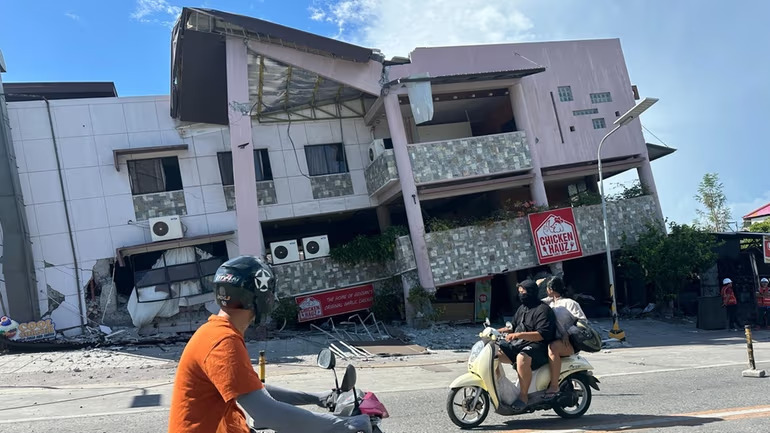
General Santos is a port city of more than 700,000 people and a regional hub for the tuna export industry and broader commerce.
The quake — the strongest to hit the country this year — was centered at sea off Mindanao, the second most populous island in the Philippine archipelago. Bacolcol said it occurred at a depth of 33 kilometers (20 miles), roughly 32 kilometers (20 miles) southwest of Maasim town in Sarangani province.
Philippine President Ferdinand Marcos Jr. ordered classes canceled and directed disaster-response agencies to begin work immediately in the affected provinces, declaring that “the national government is moving and we will not leave Mindanao behind.”
The Pacific Tsunami Warning Center said the tsunami threat had largely passed about five hours after the quake. Philippine officials lifted their own tsunami warning by mid-afternoon. Six stilt shanties in a coastal village in Zamboanga del Sur sustained damage from the quake and the elevated waves, officials said.
Assessing damage and casualties
At least 19 people were killed — most in collapsed buildings and landslides — while thousands of villagers were displaced, Office of Civil Defense spokesperson Junie Castillo said, without providing specific details.
Seven of the dead were in General Santos, where several small buildings — including a popular hamburger joint — collapsed or suffered severe damage, Sosmeña said.
The remaining deaths resulted from falling debris, a damaged mosque, and a landslide across the southern provinces of Sarangani, South Cotabato, Davao Occidental, and on Balut Island, according to Sosmeña and Dayanghirang.
Sosmeña said authorities were following up on reports of students trapped in a collapsed two-story school in General Santos. He could not immediately provide details, but national police said at least 12 people were missing in the city.
The Bureau of Fire confirmed it was conducting search and rescue operations at a damaged building and a warehouse in General Santos, without elaborating further.
Public schools across the country had reopened Monday following the April-to-May summer vacation. Dayanghirang said more than 100 students attending morning flag-raising ceremonies in his southern region suffered bruises, and some fainted in panic.
The General Santos international airport shut down temporarily, with 17 domestic flights canceled, the Civil Aviation Authority of the Philippines announced.
Manila’s DZRH radio network reported that a small commercial building housing its provincial station partially collapsed, sending staffers rushing to the ground floor unharmed. It remained unclear whether anyone else was trapped in the rubble of the four-story office building. Falling debris also struck tricycle taxis parked on the street below.
Tsunami waves near 3 feet measured
Waves of 1 meter (3 feet) were recorded broadly across the provinces of Sultan Kudarat and Sarangani. A 1.4-meter (4.6-foot) wave was measured at one point in the coastal area of Kiamba town in Sarangani, Bacolcol said.
The quake was also felt in Malaysia’s Sabah state on Borneo island — just a short boat ride from the southern Philippines. A gauge off Indonesia’s Sulawesi island recorded an 83-centimeter (2.7-foot) tsunami, and the PTWC reported 30-centimeter (1-foot) waves in Palau.
Japan’s Meteorological Agency detected waves of up to 20 centimeters (7.8 inches) on the remote island of Chichijima and in the central town of Kushimoto.
The U.S. Geological Survey placed the original quake’s depth at 55 kilometers (34 miles) — measurement differences between agencies are common in the immediate aftermath of a quake. Aftershocks reaching as high as 6.5 magnitude followed.
The Philippines ranks among the world’s most disaster-prone nations, regularly battered by earthquakes and volcanic eruptions because of its position on the Pacific “Ring of Fire,” an arc of seismic faults encircling the ocean. About 20 typhoons and tropical storms lash the archipelago every year.


Leave a Reply